
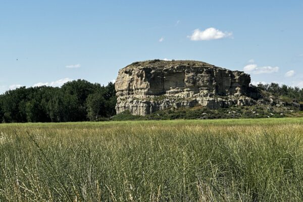
On July 25th, 1806, William Clark stopped at a 120-foot sandstone formation along the Yellowstone River in what is now Montana. He carved his name and the date into the rock face. That signature — W. Clark, July 25 1806 — is the only physical evidence of the Lewis and Clark Expedition remaining anywhere in the landscape. Pompeys Pillar National Monument Manager John Reffitt joins The Parks Podcast to share the full story: the geology, the history, the osprey nest at the top of the boardwalk, and the second W. Clark signature that was carved in 1966 as part of a centennial celebration.
A note from Missy: I’ve been to Pompeys Pillar several times. It’s amazing to witness the history of Lewis and Clark. My first visit was when I was loosely following their route out west and listening to Undaunted Courage.
Episode Guest
John Reffit – Monument Manager
Pompeys Pillar National Monument
Park Stats
- Location: Yellowstone County, Montana (near Billings)
- Designated: National Landmark 1965; National Monument January 17, 2001 (President Bill Clinton)
- Managed by: Bureau of Land Management (one of 30 BLM national monuments)
- Size: 51 acres
- Annual visitors: 22,500 (2023)
- The pillar: Rises 120 feet above the Yellowstone River
- William Clark’s signature: Carved July 25, 1806 — the only physical evidence of the Lewis and Clark Expedition remaining in the landscape
- Named for: Jean-Baptiste Charbonneau (Sacagawea’s son), nicknamed “Pomp” by Clark
- Second signature: Carved in 1966 by Frank Sindelar as part of the national landmark dedication ceremony — packed with mud and presented as a live re-enactment
- Hiking trails: 4.5 miles
- Hours: May 1–September 30, gates open 8:30am–5pm; interpretive center open 9am–4pm; open dawn to dusk year-round for walkers
- The Yellowstone River: Longest free-flowing river in the lower 48 states — passes directly below the pillar
Show Notes & Links
- Pompeys Pillar National Monument — BLM
- Lewis and Clark National Historic Trail
- Huntley Project Museum of Irrigated Agriculture
- Western Heritage Center, Billings
- Upper Missouri River Breaks National Monument — BLM sister site
- Little Bighorn Battlefield National Monument
- Bureau of Land Management — Montana
- Junior Ranger Program
Transcript
Pompeys Pillar National Monument — The West’s Most Famous Guest Book
The Parks Podcast, Episode 21 | John Reffitt, Monument Manager, Pompeys Pillar National Monument
What Is the Bureau of Land Management?
Missy Rentz: I’m excited to introduce John Reffitt, who is the monument manager at Pompeys Pillar National Monument. John, welcome to The Parks Podcast.
John Reffitt: Thank you so much. Glad to be here.
Missy: We start each episode talking about park stats. Pompeys Pillar is located in Yellowstone County, Montana. It was designated as a national monument on January 17th, 2001, when Bill Clinton was president. It is 51 acres. In 2023, you had 22,500 visitors. The land was obtained during the Louisiana Purchase. It is named in honor of Sacagawea’s son, Jean-Baptiste Charbonneau, whose nickname was Pomp. The pillar rises 120 feet into the sky. It is the only formation of its kind for several miles south of Yellowstone. And it has the signature of William Clark from the Lewis and Clark expedition on the face of the stone. Pompeys Pillar is listed as part of a unit in the National Park System, but it is managed by the Bureau of Land Management. Why is this unit set up this way, and are there other examples of this?
John: There actually are. In 1965, this property was designated a national landmark while it was still in private ownership. 36 years later, it became a national monument. Several agencies, including the Bureau of Land Management, have authority to manage national monuments — and BLM is one of those. There are 30 national monuments within the Bureau of Land Management.
Missy: What is the Bureau of Land Management more broadly?
John: The BLM is part of the Department of the Interior and has a multiple-use mandate. We manage nearly 250 million acres — more federal land than any other federal agency. It’s a sister agency to the National Park Service, the U.S. Fish and Wildlife Service, and the Bureau of Indian Affairs, just to name a few. The mission of the Bureau of Land Management is to sustain the health, diversity, and productivity of the public lands for the use and enjoyment of present and future generations.
From Private Land to National Monument
Missy: The land was first privately owned by the Foote family, and eventually the Bureau of Land Management purchased it. What led to it becoming a national monument?
John: The property was owned by Don and Stella Foote, and the BLM was able to acquire the land in 1991. At that time it was already a national landmark, and the owners wanted it to become publicly owned — meaning government owned, but also owned by the taxpayers and the constituents of this country. They, along with community groups including the Pompeys Pillar Historical Association — which later became the Friends of Pompeys Pillar — worked alongside members of the public to get this to be a monument. It takes a while. It takes a lot of letters and conversations with elected officials at every level. Finally, in 2001, it made it to a presidential proclamation. It was a lot of community support and a lot of work from the Pompeys Pillar Historical Association to get into the conversation and make it a national monument.
William Clark’s Signature — and the Forgery Story
Missy: In our fun facts, we mentioned the signature of William Clark on the face of the stone. How did they identify and verify that it was actually his signature?
John: During the Lewis and Clark expedition, the members of the party took really detailed notes — journal entries with maps, dates, times, and everything they saw — because they were reporting to President Thomas Jefferson. Clark documented his stop at Pompeys Pillar, which at the time he called Pompeys Tower. It was later revised to Pompeys Pillar in the published journals. So we have that record of the date, the time, the place, the location along the Yellowstone River — and we can surmise from all of that data, combined with identifying the actual inscription in the sandstone, that it is in fact Clark’s signature. There is a secure grate around it, and a brass and bulletproof glass cover was made over the signature years ago to protect it. It’s probably not something we would do today — it kind of creates its own little terrarium around the signature, so it doesn’t breathe that well. But it has served to protect the signature over the years.
Missy: One reason I bring that up is because there is another W. Clark signature on the pillar that is not authentic to him. Can you tell that story?
John: A few people know about this and it’s really interesting. On or around July 10th, 1966, there was a celebration for the site becoming a national landmark — about a year and a half after the actual designation in 1965. Governor Tim Babcock of Montana and National Park Service representatives attended with nearly 3,000 visitors. A group dressed in authentic 1806 period clothing floated down the river, recreating the event. A local community member named Frank Sindelar actually carved another signature similar to Clark’s on the north face of the rock facing the river. He carved it a day ahead of time and packed it with mud so that during the recreation it looked like it was being carved live. TV crews from Billings were there to record it. It was a pretty interesting event for the site — and something that obviously would not happen today. You would not go in and recreate something like that in a national landmark.
Lewis and Clark and the Yellowstone
Missy: For the rest of us who didn’t grow up in Montana — can you tell us about the history and development of the land and what Lewis and Clark meant to this area?
John: We’re just one location along the entire journey of Lewis and Clark. Their journey was pretty pivotal to things happening in the West. The East was pretty much explored by that time, and then the Louisiana Purchase happened and we wanted to know what was out there. They mapped land, rivers, and mountains that we had no records for. They brought back journals filled with information about Native American tribes and scientific notes about plants and animals they’d never seen before. They also brought back stories and tales that made other Americans dream about heading west. Some of the most important discoveries included details of the geographical layout of both the Louisiana Purchase and the Pacific Northwest — including charting the course of the rivers we now know as the Columbia, the Yellowstone, and the Missouri. Pretty huge accomplishments.
Missy: At this point in the journey, they had split up — so it was just Clark who was at this part of the journey. And when they would have gotten here, they wouldn’t have spent much time, right?
John: From all accounts, it was not more than a couple of hours that they were here. Then they got back on the river and headed toward the confluence of the Missouri and the Yellowstone, which is where they met up with Lewis. And they had no way to really communicate once they split up — no cell phones — so it’s kind of really interesting how they were able to reunite with the rest of the party.
Missy: It’s amazing. Sometimes we have a hard time finding friends with a text message. And you think about them crossing this terrain with no communication at all. The formation itself also plays a really important natural role in this story — can you talk about the benefits of the physical feature?
John: What folks will notice when they come here and look at this in person is there’s a natural ford between the rims. These rims — what we refer to as cliffs — are made of sandstone, and there’s a definite gap between the rims on the north side of the Yellowstone River. On the south side, of course, is Pompeys Pillar. It’s almost like a funnel for wildlife and also humans to cross the river and get to the other side. And this sandstone formation, which rises nearly 120 feet tall, was used almost like a check-in wall — whether they put inscriptions or signatures on there, whether they were explorers, fur traders, homesteaders, military expedition members, or Native Americans with their pictographs and petroglyphs. It’s kind of like a journal of the American West, and folks can see that when they come to visit.
Missy: And the pillar is like a guest book for all of them.
John: Yeah — exactly. Whether they were walking, had wagons, or were on horseback, this was the spot to cross over to get to points north and south. Whether it was humans or wildlife, this was a major passage in this area.
Planning Your Visit
Missy: Pompeys Pillar is located off I-94, which is a major interstate running through North Dakota and Montana. It’s very close to Billings, Montana — super easy to get to. What can visitors expect when they come?
John: What we’ve been told is it’s kind of like a mirage — because it’s such a nice place off the beaten path from the interstate. When you drive in, you see green grass, a nice interpretive center with sidewalks and restroom facilities. Folks park and start walking. They can explore our visitor center, where rangers are there to explain what’s here and what they can find. We have ranger talks as well, and inside you can view several videos we’ve put together to explain the culture, the surroundings, and what’s special here. There’s the boardwalk where folks can actually walk up and take 360-degree views of what’s around them — a pretty good vantage point. There are birds and all sorts of different wildlife to notice as well. And we do have a trail system — about four and a half miles — so folks can take a short loop or a longer loop if they like.
Missy: It’s so engaging and such a great activity for kids. And the Yellowstone River plays a really important role in this area.
John: The Yellowstone River is the longest free-flowing river in the lower 48 states. Many folks may not know that, but it’s important today for travel, irrigation, and drinking water for several communities. Even back then, they used it for commercial trade — steamboats went up and down the Yellowstone. It is a unique river and a nice testament to how there are still rivers like this in the United States. We also have a Junior Ranger program here — kids can use that booklet to achieve Junior Ranger status, and we’ve got the badges and everything.
Missy: Pompeys Pillar is one of those where it’s a great pit stop. You’re not spending days here. You can do it in as little as an hour and still feel like you had a really meaningful visit. The visitor center, the ranger programs, the walk up the stairs to see the signature, and then a little further to the incredible overlook where you can see for miles on a beautiful day. Let’s talk about safety and what people should be prepared for.
John: Bring water — even though we’re not in the middle of nowhere, it’s still quite a walk, especially climbing up the steps. But it’s not too difficult. There are places to rest and some walkways incorporated, not just all steps. We’re outdoors and in the natural elements so there’s all sorts of wildlife, but nothing too worrisome. If you come during the summer, especially July and August, we do have some mosquito population just because we’re so close to the river. Having bug spray available is a good idea. But what’s really good about that is you’re experiencing the same thing that William Clark and the rest of the expedition experienced when they came through this same area. Just with better options today to keep them off you.
Missy: And it is nature, so you can see a lot of wild animals. When I was there, the rangers were excellent at educating — I don’t want anybody to go to parks with fear, because the rangers are there and they love to help you. When I arrived, they mentioned there was a rattlesnake den nearby that they were keeping an eye on — nothing to worry about, but just something to be aware of. There was a ranger in that area and we walked around it. You’re in nature. There’s all sorts of animals.
John: We’re in their environment. Whenever you go outside, you can expect to see wildlife, especially in a natural setting like here. They tend to stay to themselves, but this is their home. Best to keep an eye out and stay on the trails and the sidewalks. You should be fine.
Missy: What other animals have you seen out there?
John: We’ve seen whitetail deer, mule deer, marmots, raccoons, badgers, and red fox. There was a black bear sighting back in 2011 — a long time ago — but you just never know. Wildlife migrates and moves around. And definitely plenty of birds and eagles. When you climb up to the overlook, there’s an osprey nest up there and a ranger to tell you about it. There’s even a set of binoculars people can look through. The bird viewing is incredible from up there — you’re high enough that you’re at the same level as where they’re soaring. A lot of folks come out especially when someone posts that they saw a certain bird, and then more birders come to see it too. It’s a really diverse place to see bird activity and migrations.
Missy: As you’re coming in or out, there’s a pullout with old farm equipment. What’s the importance of that display?
John: That interpretive area is to share with visitors the importance of agriculture in the Yellowstone Valley and feature some of the equipment used years and years ago. The items are on loan from the Huntley Project Museum. Montana is actually a very important farming region — even if people don’t immediately think of it that way.
Missy: What other information should people know when planning their trip?
John: We are open every day from dawn to dusk. The gates to the site open May 1st through September 30th, from 8:30 a.m. to 5 p.m. You can walk in year round, but if you want to drive in, it’s 8:30 to 5. The interpretive center is open from 9 a.m. to 4 p.m. You may also want to check out other local attractions: the Huntley Irrigation Project Museum, the Western Heritage Center, the Yellowstone County Museum. And check out the other national monuments in Montana, including our sister BLM site, the Upper Missouri River Breaks National Monument, and the Little Bighorn Battlefield National Monument. Those are the three national monuments in Montana.
Speed Round
Earliest park memory?
Camping with my family during the summer. We always looked forward to it — whether it was by a lake or in the forest, it was just fun to be out in nature.
What made you love the parks?
When I was growing up and visiting these places, I thought — there are people that actually work here. I could do this. I like being outside. I like working in nature. And I found just a love and adoration for being outside and also introducing folks to the outdoors.
Favorite thing about Pompeys Pillar?
The view from the top overlook. Being able to see so many miles away — different mountain ranges, the landscape, the river. It’s pretty cool.
Favorite thing to do at Pompeys Pillar?
Making the place look good and presentable — just delivering a good experience to the visitors and the public we serve.
Park on your bucket list?
Yosemite. I’ve heard a lot of good things. It’s not too far away, but that would definitely be one on my bucket list.
Three must-haves for a park visit?
Water. A little snack. And a map, so I know where I’m at.
Favorite campfire activity?
S’mores. That’s my go-to — campfire and s’mores.
Tent, camper, or cabin?
We’ve done tents, but we have hammocks too — so that makes it not too bad.
Hiking with or without trekking poles?
I haven’t done trekking poles yet, but I’ve heard a lot of good things. I’d like to try them out now that I’m not so young as I used to be — I think they could come in handy for rugged terrain and that extra stability and momentum.
Favorite trail snack?
Trail mix.
Best animal sighting?
Grizzly bears at Yellowstone.
Favorite sound in the park?
The birds — all different kinds, just having them talk away. It’s good to hear that.
Greatest gift the parks give to us?
A lot of folks don’t know about parks. They don’t know that there are special places out there that are ours — ours to enjoy. Getting away from the highways and the concrete jungles and just the noise — to get to that peace and quiet and hear those natural sounds. That sense of solitude that you can find in some places, where you feel like you’re the only one there and that’s okay. That’s what they’re there for. They’re there for you to explore and enjoy.
Missy: John, thank you so much for taking time to chat with us and tell us the story of Pompeys Pillar. I love this place, and I really hope listeners take time to visit when they’re on their way through Montana.
John: Well, thank you so much, Missy. I appreciate the time.
Missy: That’s it for today’s episode. Until next time — we’ll see you in the parks.
Music for The Parks Podcast is performed and produced by Porter Hardy. Follow us @TheParksPodcast or visit TheParksPodcast.com.